CHAPTERTHREE:
WATER RESOURCES
SURFACE WATER
The surface waters of Branford (Figure
4; Surface Waters) are generally oriented in a north-south direction
and are the result of drainage ways associated with the last glacial
period that ended about 18,000 years ago. These water courses of
Branford can be classified by the type of water including freshwater
inland systems such as flowing streams, rivers, ponds and intermittent
watercourses, and coastal systems such as tidal fresh, brackish
and salt watercourses.
Non-tidal Inland Freshwater
The freshwater resources of Branford include a variety of streams,
lakes, ponds and rivers ranging in size from small vernal pools
and feeder streams to Lake Saltonstall and the Branford River. Intermittent
watercourses are those that have a defined channel and exhibit some
form of surface flows such as alluvial sediments (sands and muds
carried by water) or wrack (plant debris or floatables that come
to rest in tree branches or rocks). Water flow in these areas occurs
only during rain events. These are scattered throughout the landscape
and are often incorporated into lawns and open fields.
About three quarters of the Town of Branford is served by two drainage
basins: the Branford River and the Farm River. The remaining approximately
25% of the Town is drained by a series of smaller individual basins
that drain directly into Long Island Sound and are most common in
the eastern portion of Town. Of the basins in the Town, the Branford
River is the largest single basin and accounts for about 45% of
the Town's area. The Farm River is the second largest basin and
accounts for about 25% of the Town's area.
Branford
River Basin
The Branford River is part of the South Central Eastern Regional
Complex of the South Central Connecticut Coastal Basin. The main
stem of the Branford River extends about 10.5 miles in length and
the watershed drains an area of approximately 15,750 acres or just
under 25 square miles. The River begins just south of Lake Gaillard
in North Branford and ends at the Branford Harbor in Branford before
emptying into Long Island Sound. The river drops in elevation from
a high of 600 ft at its headwaters at Crooked Brook to sea level
at the Sound. The river can be divided into two main sections: a
freshwater non-tidal portion that encompasses about 17 square miles
(10,800 acres) and a tidal portion that accounts for the remaining
8 square miles of area (5,100 acres). The entire watershed is located
in New Haven County with much of the area (>90%) within the Towns
of North Branford and Branford with the remainder in Guilford. The
last 4.3 river miles are tidally influenced and include both brackish
and saline portions.
Approximately 40% of the watershed is developed with residential,
light industrial, and commercial uses. The remaining 60% of the
watershed contains over 8,000 acres of mature secondary post agricultural
forests and wetlands and another 2,000 acres in agriculture and
parkland.
Sub-watersheds/Basins
The Branford River watershed contains five primary tributaries:
Munger Brook, Notch Hill Brook, Queach Brook, Mill Creek and Sybil
Creek, the latter three of which are primarily located within the
Town's boundary. The Connecticut State Department of Environmental
Protection considers the end of the Branford River Watershed to
be located at the Penn Central Railroad crossing just upstream from
the Route 146 bridge on Montowese Street. South of this point the
River is considered coastal and is tidally influenced. Between the
Penn Central Railroad and I-95 the river is brackish and tidal while
above I-95 (at Ward's Dam) the River is freshwater and non-tidal.
The freshwater non-tidal portion of the Branford River within the
Town can be divided into three sub-watersheds: the Upper Branford
River sub-watershed, the Pisgah/Queach Brook sub-watershed, and
the Ward's Mill Pond sub-watershed. The tidal portion of the river
includes two smaller freshwater sub-watersheds: the Mill Creek and
Sybil Creek systems.
The Pisgah/Queach Brook sub-watershed is one of the most important
systems, because it includes the Branford Supply Ponds and some
of the most pristine habitats in Town (Pisgah Brook). This sub-watershed
also contains Pine Gutter Brook, an area that, although it still
maintains good water quality, is experiencing significant erosion
due to loose soils, steep slopes, and poor planning. This erosion
has caused a major sedimentation event in the Supply Ponds and threatens
water quality throughout the system. Attempts to manage this resource
are being implemented; however, until the landscape reaches equilibrium,
erosion will continue to be a problem throughout the Supply Ponds
and lower Queach Brook.
The tidal portion of the river includes all river points south of
Ward's Mill Pond Dam. This portion of the Branford River is the
most developed within the watershed. Between Ward's Dam and Route
1, the river is tidal and the waters are freshwater to slightly
brackish. Between Route 1 and the Branford High School, the area
supports brackish tidal marshes before giving way to saline tidal
marshes south of the Penn Central rail lines. Two main tributaries,
Mill Creek and Sybil Creek, drain into this portion of the River.
Mill Creek is a highly urbanized drainage system that contains about
25% impervious surface within its boundaries. This is quite extensive
for a small sub-watershed such as this and has, consequently, caused
significant flooding within the sub-watershed basin. Sybil Creek
is a small tidally restricted tributary located in the lower Harbor.
About two thirds of the tributary is located above tide gates at
Route 146 and the upper reaches include both active and inactive
landfills. Its confluence with the harbor is near the outfall pipe
for the Town of Branford's Sewage Treatment Plant.
Due to the presence of tides and its proximity to downtown, this
portion of the Branford River system has the least favorable water
quality and is generally rated between B and AA. The sewage treatment
plant has its outfall in the middle of the river and further contributes
to decreased water quality in this stretch of the river. An upgrade
to the sewage treatment plant is currently underway and should help
improve some of the water quality in the River.
Farm River Basin
The Farm River watershed drains the entire western portion of the
Town and shares a drainage basin with East Haven and North Branford.
The drainage divide between the Farm River and the Branford River
is delineated by the high angle Jurassic fault (Totoket Mountain
Ridge - see Geology Chapter). The Farm
River system in Branford can be divided into two major sub-watersheds:
the freshwater Lake Saltonstall and its surrounding lands and a
lower tidal portion. Much of the land surrounding Lake Saltonstall
is protected by Regional Water Authority (RWA) landholdings. Boating
and some recreational uses are permitted on Lake Saltonstall and
residential development does occur between RWA lands and Brushy
Plain Road.
South of I-95, the Farm River flows through some dense residential
areas before becoming tidal south of Route 100. Poor planning and
insufficient floodplain areas have caused some flooding problems
in the system during the last few years. The Town of East Haven
has attempted to try to dam some of the upstream areas; however,
the State has not been receptive to these plans. Towards the mouth
of the system, the Farm River supports some salt marsh habitats
and small drainage ways.
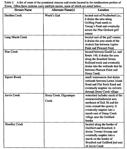
Individual Basins in the Eastern Portion Of Town
The eastern portion of Branford is drained by a series of smaller
drainage basins that separately drain into Long Island Sound (Table
2: Streams). These smaller streams and drainage ways are generally
found in only moderately developed portions of Town and their water
quality is typically an A rating. Within this portion of Town are
the Stony Creek quarries and Tilcon Company holdings. Due to the
gentle slope in topography, many of these streams contain large
swamps and freshwater marshes. The tides in these systems vary depending
on the topography of the land and land-use considerations and many
of these smaller streams are restricted at the mouth and regulated
by tide gates or sluice gates (i.e., Jarvis Creek). Even though
tides have been restricted in the areas, they do continue to support
relative large tracts of coastal marsh habitat.
Tidal Waters
The coastal resources are typically defined by the presence of tides
(both historically and presently). Tidal range in Branford Harbor
is 5.9 ft (almost 1.8 m) and relative sea level rise (submergence)
is about 0.12 inches/year (3 mm/year). Salinities in these systems
can vary from fresh (<0.5 parts per thousand) to brackish (0.5 to
ca. 18ppt) to salt water (ca. 18+ ppt), depending on flows and upland
runoff. Through the years, the tidal flows in many of these systems
have been interrupted due to development, roads, railroads, and
flooding concerns. The habitats located upstream of these tidal
restrictions are typically in some form of degradation and many
are supporting freshwater and brackish conditions where saline waters
once dominated. Even in those systems that have not been tidally
restricted alterations to tidal hydrology due to ditching, dredging,
and storm water discharge have instigated vegetation and habitat
changes as well. Thus, with the exception of some small isolated
areas directly open to Long Island Sound, all of the tidal systems
within Branford have been significantly impacted by human activity.
GROUND WATER
Although the information on ground water resources in the Town is
somewhat limited, it is evident that the ground water is generally
good quality for much of the Town (Figure
5; Ground Water). The aquifers associated with the Branford
River and the Farm River appears to be maintaining good water quality
throughout (generally Class A ratings). In Branford, the largest
area of recharge is Lake Saltonstall and to a lesser extent the
Supply Ponds, and Lindsley Pond. Much of the recharge for the region
is actually associated with Lake Gaillard in North Branford (which
is also the main source of surface waters in the Branford River
and to a lesser extent, Lake Saltonstall and the Farm River system).
Although groundwater quality is good, there are some areas in Town
where leachates have polluted the underground aquifers. The most
prominent example of a problem area is the aquifer associated with
Sybil Creek and the old Branford landfill (see Chapter
7 - Problems). The landfill, which was closed years ago, is
still leaching some volatile organics into the groundwater and has
formed a plume that is running generally in a westerly direction
(following the drainage way of Sybil Creek). These plumes have been
monitored since the mid-1980s by Fuss and O'Neill Inc. and are generally
not considered hazardous to environmental health of the area. Concern
about the leachate did force residents in the area to abandon well
water and switch to city water during the late 1960s and early 1970s.
WETLANDS
The wetlands of Branford cover a large range of habitats and size
(Figure 6: Wetlands). Almost every wetland
type found in Connecticut can be found in Branford in one form or
another. These wetlands include small pocket marshes dominated by
grasses, large red maple swamps, a remnant cedar swamp, and a variety
of tidal marsh systems. The wetlands themselves range from somewhat
pristine to highly disturbed and vary in their state of preservation.
Although the State of Connecticut delineates its wetlands based
on soils, the wetlands noted here will be based on vegetation (for
additional information on vegetation see Chapter
4 - Biological Communities) and habitat characteristics more
commonly used in the rest of the country. The term swamp refers
to areas dominated by woody plants, bog refers to areas with shrubs
and mosses, shrub/scrub refers to low bushes and marshes refer to
areas dominated by herbaceous vegetation, primarily grasses.
Swamps are scattered throughout the Town and vary in size from small
pockets to large expansive systems. The vast majority of swamps
are associated with the smaller rivers and streams that dot the
landscape and are common along a number of the smaller streams located
in the eastern section of Town. Although there can be a mix of a
number of varieties of tree species (i.e., white oak, pin oak, willow),
these systems are typically dominated by red maple. One of the prime
examples of a red maple/mixed hardwood swamp can be found along
Towner Swamp Road. The only example of a cedar swamp is a swamp
remnant located in the eastern portion of Town. Coniferous wetlands
are also not very common; however, an example of a hemlock/pine
wetland can be see in and among the ravines in North Farms Park
off of Route 139 in North Branford.
There are very few bogs in Town and when they do appear they are
typically very small in area and typically mixed in with maples
and oaks. An example of this type wetland can be seen along Pisgah
Brook where the utility right-of-way has maintained an open canopy.
The shrub/scrub wetlands can also be found in this area and dominates
much of the lowlands associated with the right-of-way. In addition
to the shrubs typical of these wetlands, the plant community is
often interrupted by a variety of introduced and invasive species
(i.e., multiflora rose, Japanese honeysuckle). One of the best examples
of a shrub/scrub wetland in Town can be seen along Quarry Road off
of Leetes Island Road.
Marshes are one of the most dominant types of wetland in Town. They
include the inland freshwater marsh and the more common coastal
marsh and coastal marsh remnant. When inland freshwater marshes
do exist they are generally found interspersed among breaks in the
canopies of swamps and shrub/scrub wetlands. One of the nicest examples
of a freshwater sedge marsh can be found off of Eastwood Road (off
Route 146).
The largest single type of marsh is the coastal tidal marsh. These
systems vary between tidal freshwater to brackish to salt marsh
and are generally found south of Route 1. Tidal freshwater marshes
are located at the head of tide where freshwater flows are sufficient
to keep salinities very low but still allow tidal action. Although
rare, they do exist at the heads of a number of tidal streams (some
can be seen along the Branford River and Queach Brook where they
cross Route 1). Brackish marshes are more common than their freshwater
counterparts and many of them can be seen along the Branford River
between Route 1 and the high school.
By far, the most common type of tidal wetland is the salt marsh
and the salt marsh remnant. These can be seen along almost every
river and stream that empties directly into the Branford Harbor
or LIS and is best exemplified by the system off Route 146 behind
Lenny's Restaurant (see below). Other fine examples include the
lower Farm River and the systems associated with Jarvis Creek in
the Stony Creek section of Town.
A good example of a typical Branford tidal system can be seen at
Sybil Creek. The marshes and channels west of Route 146 (downstream)
have not been restricted. However, the mouth of the system has been
dredged for boat activity and the marshes within the system have
been ditched for mosquito control. Today, these marshes are eroding
and showing signs of increased flooding (ground is hummocky and
marshes are beginning to fragment into open pannes). Above (east)
Route 146, it is a different story. Route 146 acts as a barrier
to tides and limits flooding due to a series of one-way flapper
tide gates (these gates were first installed during the 1920s to
allow rainwater out of the system while keeping tidal waters west
of Route 146). Today much of the system above Route 146 is dominated
by reedgrass (in the past these marshes resembled the marshes and
channels we see today west of Route 146). The changes seen in Sybil
Creek are common throughout the State.
Programs to restore these restricted systems are currently being
pursued by the State DEP. Many require engineering solutions to
fix the problems and all will have the goal of reintroducing some
amount of tidal flow to the area. One place where nature has restored
some of the marshes is east of Montowese Street and south of the
Amtrak railroad near Tabor Lutheran Church and Sansone Farm. Originally,
the marsh in this area was dominated by salt marsh grass. A tide
gate was fitted on the Montowese Street Bridge sometime during the
late 1940s. Soon after, reedgrass began expanding out onto the marsh
as salinities fell behind the gate. During the early 1970s, a storm
blew the gates off its hinges and full tidal flushing was once again
introduced into the area. During the last 30 years, salt marsh grasses
have recolonized in many areas where reedgrass once stood.
Recently the inland wetland regulations in Town were rewritten to
further protect non-tidal freshwater wetlands and adopt a "no net
loss" policy for the Town. For further information about wetland
regulations contact the Inland Wetland and Watercourse Agency for
inland wetlands and the Town Planning Department for coastal systems.
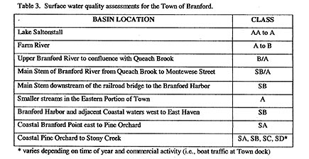
WATER QUALITY
There are a number of factors that may be considered in assessing
water quality in Town (Figure
4, Figure 5) including
dissolved oxygen (DO), biological oxygen demand (BOD), nutrient
loading (nitrates, ammonia, phosphates), bacterial counts (coliforms)
and heavy metal concentrations (mercury, iron). The concentration
of any of these can vary within a watershed due to flushing rates,
point vs. non-point pollution sources, and land-use activities within
the watershed. Any classification of these categories are generalized
and do not assess any one point on the river. Therefore caution
must be used in interpreting water quality standards; a very high
rating does not necessarily mean that there are no problem areas
within the designated zone.
According to the State of Connecticut's "Water Quality Standards"
(DEP 1992), much of the surface waters of Branford fall into the
category of "good" quality water. For example, the entire length
of the Branford River is suitable for swimming and fishing. The
Water Quality Classifications for the major surface waters of Branford
are shown in Table 3.
Class AA is the highest quality water designation and can be used
as drinking water supply. Class A applies to waters that are of
sufficient quality that they can be used for drinking water supply
in the future; Class B refers to water quality as fishable and swimmable
but not drinkable; Class C & D are problem waters not included in
the watershed. An "S" designation denotes coastal or marine surface
waters and multiple designations (i.e., B/A) refer to the present
water quality and the water quality goal for the area, respectively.
Groundwater quality also follows the same designations. GAA is the
highest water quality and is a direct potable supply. GA is also
potable and is intended for future use and may require some additional
filtering. GB is not potable and cannot be used for consumption.
|