CHAPTER
SIX : RECREATION/OPEN SPACE
RECREATION
Branford maintains a number of recreational sites throughout the
Town (Figure 11). These
include parks and ball fields, boat launches, docks, and beaches.
The Town also maintains Open Space (Figure
12) through various land holdings including Town, State and
Federal, and quasi-public entities such as the Branford Land Trust,
Inc. and the Regional Water Authority. Many of the open spaces noted
below are also used for passive recreational activities such as
hiking and bird watching. In all, Branford has over 3,500 acres
of open space (Appendix IV: Recreation
and Open Space) and devoted recreational fields for outdoor
activities.
Parks
At present the Town maintains 53 recreational facilities. They range
in size from a ball field to the natural areas surrounding the Supply
Ponds. Facilities vary at each park although most maintain open
fields for sporting activities (i.e., soccer, baseball). A list
of the parks and their major facilities are noted in Appendix
IV.
Some of the more notable parks include the Supply Ponds Preserve,
Pisgah Brook Preserve, Stony Creek Quarry Preserve, Parker Memorial
Park (Branford Point), Foote Memorial Park (owned and maintained
by the Foote Family Charitable Trust), Young's Pond Park and Veterans
Memorial Park. The Supply Ponds encompasses about 350 acres of open
water and forested land that support a variety of recreational activities
including fishing, ice skating, hiking trails and picnic areas.
Foote and Veterans Memorial Parks are used for a variety of activities
including athletic fields and tennis courts. Young's Pond Park has
ball fields and a dog park where area pets can run free off leashes.
Area schools also provide recreational facilities such as the recently
completed multimillion-dollar renovation at the High School (fields
and tennis courts) and an indoor pool at the Walsh Intermediate
School.
Being situated along the coast, Branford also supports a diverse
number of coastal activities such as boating, fishing and bathing.
The Town's public beach is found at Parker Memorial Park at Branford
Point. The Town has a boat launch at Stony Creek and the State maintains
a boat launch off Goodsell Point Road on the Branford River. A number
of private marinas are present along the Branford River, the Farm
River and at Stony Creek. Stony Creek also provides tours to the
Thimble Islands as well as seal watching and fishing expeditions.
In the western portion of Town, an old trolley line still offers
rides to the public. This line is associated with the Shoreline
Trolley Museum located in East Haven and is the oldest operating
trolley museum in the country.
OPEN SPACE
For purposes of this report, open space will be defined as an area
that is not used for any one recreational activity (passive recreation
only) and is not a managed park. This would include conservation
and land-trust holdings, wildlife areas and land set aside for water
quality purposes (Regional Water Authority) (Figure
12, Appendix IV: Recreation and Open Space). Open space varies
around Town from lands dedicated to conservation to lands that serve
multiple purposes. Throughout the Town, there are many private parcels
of land that have not been developed (for some reason or another)
and have become "de facto" open space lands (e.g., some of the lands
along Pisgah Brook, the old gravel pit to the north of the landfill).
Since these lands are not public, nor are they sanctioned open space,
they will not be included in this report except where they form
an important wildlife corridor (see below).
The information presented on Figure 12 is in draft form and is not
a complete accounting of open space just yet (it still requires
additional information and editing). Even though it is not complete,
it still provides important baseline information for the NRI. As
noted earlier in this report, the NRI is not meant to be a static
document and this is one of the areas of information that can be
updated as it becomes available.
Cemeteries
Although cemeteries are not dedicated to recreation or conservation
activities, they do form open space in the Town and provide for
vistas on occasion. The location of the major cemeteries in Town
is noted on the Recreation/Open Space Map.
Regional Water Authority Land
The lands surrounding Lake Saltonstall are devoted to maintaining
water quality and have not been developed. At present, the Water
Authority has over 1,070 acres associated with Lake Saltonstall,
and a variety of smaller holdings throughout the Town (i.e., 11.6
acres at Ward's Pond, 50.90 acres along the Branford Connector at
Exit 53 on I-95). A more detailed account of the Water Authority's
holdings is shown in Appendix IV. Some hiking and boating activities
are permitted on these lands.
Conservation, Wildlife Areas and Land Trust Lands
Conservation and Land Trust lands are dedicated as open non-developable
land. Many of the conservation lands are small parcels associated
with developments over the years, although the Town does maintain
some larger parcels such as those on Summit Drive and Brook Lane.
The Town has four main parcels set aside as wildlife areas. These
include a series of marshes on Long Marsh Creek and Pine Creek between
Pine Orchard and Stony Creek, part of the marsh on the north side
of Indian Neck, a site along the Farm River, and the larger Branford
River Wildlife area located between Ward's Pond and Route 139. These
sites are dedicated to providing valuable habitat for the protection
of wildlife resources. These are not recreational areas and are
limited in access whenever possible.
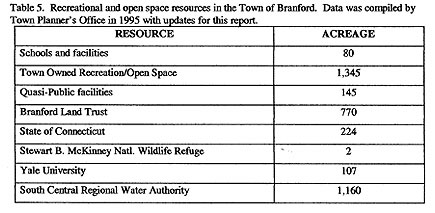
The Branford Land Trust has about 770 acres in its holdings (as
of April, 2003). These range from a small parcel of less than a
third of an acre at Pine Orchard Road to the 105 acre Van Wie Preserve
between Red Hill Road and Flat Rock Road. All of these sites will
be kept undeveloped and some may be used for passive recreation
such as hiking. A complete listing of their holdings can be found
in Appendix IV.
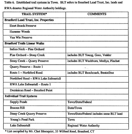
Trail System
At present there are a number of hiking trails located throughout
the Town located on public and quasi-public lands (Figure 13 - 2001
Inventory of Branford Trails; reprinted from South Central Regional
Council of Governments Preliminary Trail Inventory for Branford,
CT). Official trails have been established in the Supply Ponds Preserve,
within the Regional Water Authority's land around Lake Saltonstall,
along the old Stony Creek Trolley Line, Young's Pond Park and Stony
Creek Quarry Preserve, among others. At present 83 % of the proposed
trail system has been established (373 miles out of the 449 miles
proposed) (Table 6: Trails). Attempts have been made to make this
system more continuous and uniform around Town; however, there are
portions of the trail that are still discontinuous pathways that
include roadways and patches of private land. Plans are also being
considered to connect these trails to a larger trail system, the
Shoreline Greenways Trail, that will run continuously along the
Connecticut shoreline from Lighthouse Point in New Haven to Hammonasset
State Park in Madison. For more information contact the Conservation
and Environment Commission.
Wildlife Corridors
Throughout the Town, important wildlife corridors can be identified
in both public and private lands. In many cases, these corridors
differ from what they were historically because many of the natural
areas in Town have been developed. A wildlife corridor can range
from dedicated conservation lands to railroad and utility right-of-ways.
Wildlife corridors can come in many forms depending on the animal
species being considered. For example, the storm drains around Town
may be considered corridors for rats and raccoons. However, for
larger organisms or those more sensitive to urban development, corridors
are the more traditional open spaces around Town. Since the storm
drains are not in danger of future development, they will not be
considered further here.
The largest contiguous tracts of land that have not been developed
are those associated with rivers and streams. These areas have,
therefore, become the primary corridors for wildlife movements in
Town, even though a number of species would prefer not to traverse
wet environments. Small steams and wetlands connect almost all of
the landscape and allow for the movement of animals throughout the
Town. Utility right-of-ways also provide a significant corridor
for many species. Often an animal that wants to move through Town
must deal with a variety of different type corridors for an individual
trip and may use open space, roadsides and even people's back yards
to make the journey. Although there are places for animals to migrate
through Town, most are highly fragmented and at some point require
crossing major roads. This is perhaps the most hazardous portion
of their journey. Unfortunately, some of the most important corridors
are privately owned and many could face development in the future,
further stressing animal populations in Town.
Since the majority of corridors are associated with drainage ways,
it is important that this resource be protected from further development.
It would not be practical to identify all of the wildlife corridors
in Town within the budget constraints of this NRI. However, there
are some important corridors that are considered below.
The Branford River Basin
The Branford River and its associated habitat is a major corridor
north of I-95. The river maintains an almost continuous string of
habitats from Lake Gaillard to Ward's Dam and is not only an important
corridor but habitat resource as well. Below Ward's Dam, development
and channelization of the River limits the main stem of the river
as a corridor. Instead tributaries such as Queach Brook and Pisgah
Brook provide an important corridor alternative between the upper
reaches of the basin and the coastal portions south of Route 1.
Since most of the development in Town is concentrated below Route
1, the wildlife corridors become more circuitous towards the coast.
For example, to travel from Route 1 to the shoreline, an animal
can use the marshes below the High School to Tabor Drive. At Tabor
Drive, the corridor turns along the railroad tracks to the old Cosgrove
gravel quarry. From here the path generally moves through the Branford
landfill to the Town-owned woods located at the end of Waverly Park
Road. This leads to the Sybil Creek marsh system and the coast.
The Farm River Basin
Lake Saltonstall and the Regional Water Authorities lands are important
corridors and habitat in the western portion of Town. Although the
Farm River does connect to this drainage way it is interrupted by
Route 1 and a number of developments as it winds its way through
East Haven and out to the Long Island Sound. Wildlife corridors
in the area are pushed into the smaller streams, along yards of
private homes and areas adjacent to Pent Road. Although the lower
Farm River Basin does have some open habitat in the tributaries
(e.g. Minore marsh), these too are interrupted by residential development
along the banks of the River and the route is often more circuitous
for the animals (they must actually move through the tidal marshes
in places which could be problem at high tide).
Other Basins
Perhaps the best concentration of wildlife corridors is found in
the eastern portion of Town. A combination of fewer residential
developments and large undeveloped tracts associated with Tilcon
and Stony Creek Quarry operations has kept this portion of Town
free from major interruptions in wildlife corridors. The Tilcon
rail-line also provides a good north-south orientated corridor that
can also reach Lake Gaillard in North Branford. In addition, the
abundance of smaller drainage basins provides a greater choice of
corridors, particularly between the coast and inland areas. Not
only do we see more uninterrupted corridors in this section of Town,
the presence of large open spaces such as Towner Swamp, various
Land Trust holdings, and the broad open shrub/scrub wetlands located
along Quarry Road provide excellent habitat for many of the migrating
species as well.
|