CHAPTER
FIVE: LAND-USE
Branford has had a rich and diverse land-use history. Some minor
historical accounts will be presented here to show the changes that
have occurred and relate modern land-use to the last 300 years of
settlement. For more information about Branford's history visit
the Blackstone Memorial Library or contact the Branford Historical
Society (124 Main Street; 488-4828).
Transportation Corridor
After its settlement during the 1600's, Branford remained a farming
community and small town for much of its existence. It is only during
the last half of the Twentieth Century that much of the land was
developed for residential and commercial uses. Therefore, much of
the character of this Town has changed within the last 100 years.
One of the most important impacts on land-use in Branford during
the last 100 years is the advent of a large transportation corridor
between Boston and New York (Figure
9: Land-use). With the building of the railroad, the development
of Route 1, and the origin of Interstate 95, the whole coast between
New York and Boston changed dramatically. Much of the Town's present
character and, subsequently, its land-use are tied to this corridor.
Residential development and supporting commercial interests (strip
malls and shops) account for the vast majority of development in
Town. Light industrial and commercial developments are a distant
second to residential development and farming is relegated to a
few scattered sites around Town.
The effects of the transportation corridor can be seen in the distribution
of land-uses throughout the Town. Most of the commercial and industrial
development in Town takes place along the Route 1 corridor. South
of I-95 (which includes both Route 1 and the rail line) is the highest
density of houses. You can almost trace the position of Routes 1,
146, 139 and 142 by following the coded symbol noted on Figure
9 (Land-use) for residential/commercial development. This same
approach can also be taken to map out the Branford Green and the
areas surrounded by Main Streets. The least developed portions of
Town are located north of I-95 where major thoroughfares are fewer.
However, here too, one can follow the path of Brushy Plain Road
by following the increase in housing and commercial densities. The
least developed portion of Town is the area associated with the
steep topography along the high angle Jurassic fault (Totoket Mountains),
particularly those areas underlain by basalt deposits. The largest
sections of uninterrupted open space are located north of I-95 in
the Supply Ponds subwatershed, and on lands belonging to the Regional
Water Authority (Lake Saltonstall subwatershed). The next largest
tracts of uninterrupted open space are located along the eastern
portion of the Town along the Branford/Guilford border.
With the exception of Lake Saltonstall, the Supply Ponds and the
undeveloped areas along the eastern Town border, the forested areas
in Town are highly fragmented. Most of these habitats are secondary
growth and recently disturbed secondary growth deciduous forests.
The last remaining contiguous tracts of coniferous forest are those
located on Regional Water Authority land, some isolated tracts within
the Supply Ponds sub-watershed and some isolated patches in the
east and northeast corner of Town.
RESOURCES
Land-use in and around Branford is tied to the geology in many ways
(compare Figure 1, Figure
3 and Figure 9).
For example, farms were most prevalent on the broader flats that
overlie the glacial outwash plains while mining and quarry activities
are more common where bedrock reaches the surface or glacial debris
deposits are found. Although utilized throughout its history, the
high angled fault region is the least developed area today because
of the steep slopes and rough topography.
Farms
Early European settlers to the Town found ample forests and resources
to survive. Like so many coastal areas of Connecticut, the open
salt marshes provided grazing and other open space for early use
in maintaining livestock. This coastline also provided food (fish,
shellfish), pelts (e.g., muskrat) and other economic opportunities
as the Branford River provided a good harbor and inland waterway
for its early residents. The forests that had grown since the last
glaciation were well developed hard and soft wood habitats and provided
the early settlers with abundant building material.
As the land was cleared, the glacial tills provided good drainage
to many of the soils and farming was readily accomplished. The Branford
River was a good source of freshwater and irrigation was possible.
The sloping topography, moderate yet moist climate (regulated by
the proximity to the coast) and the sandy soils were especially
good for the planting of orchards.
Coastal and Off-shore
Due to the Town's proximity to the shoreline, many opportunities
are provided for residents to utilize the coastal and offshore resources.
Early in its history, shellfish beds, including oysters, were available
to the residents of Town. Commercial fishing in the Sound and near-shore
area was also important. Beaches and access to the water have long
served Branford's residents and in the past (early 20th Century)
made tourism a relatively large trade. Today, coastal rentals still
provide a source of income for a number of landowners, although
most properties are now year-round residences. Coastal resources
also include boating and access to the water. Branford has over
10 marinas and yacht clubs along the Branford and Stony Creek Harbors
alone. The Farm River, Lake Saltonstall and upper reaches of the
Branford River and its tributaries serve a number of purposes including
canoeing and boat launches and rentals for smaller boats.
Today, although access to many of the offshore and coastal resources
are restricted at times due to pollution, there are still many uses
of the offshore habitat by Town's residents. Lobster and clams (steamers
and round) are still important seafood resources to the region.
Crabs are also locally important. Fish such as shad, that were probably
present at one time in the River, are now no longer part of the
catch. Flounder, fluke, blackfish, bluefish, porgies (scup) and
weakfish are still taken in the gray and blue waters off the coast.
Most of the coastal fisheries are almost exclusively an offshore
resource. Near shore and coastal resources are now limited to clamming
and some limited crabbing, although these too are subject to closure
depending on the tide and storm activity (see Figure 10 - Recreational
Shellfishing in Branford; reprinted from Branford Shellfish Commission
Brochure, January 2002). Other shellfish include blue mussels, oysters
and razor clams (Figure 10: Shellfish Beds).
Some important commercial and sport fish include sunfish, trout
(rainbow, brook and brown), wide-mouth bass, striped bass, flounder
and sea trout. Bait-fish such as killifish and silversides are also
part of the resource (for more information see Biological
Communities Chapter).
Thimble Islands
Within Stony Creek Harbor there is a collection of over 350 islands
that form the Thimble Island chain. These islands, the result of
a fault line scarp (thrusting), range in size from just a half acre
to 12 acres and support a variety of land-uses including residential
development and habitat conservation. While some of the islands
do support houses, most are too small for residential use. Many
of these smaller islands are home to birds and seals and some are
part of the Stewart B. McKinney National Wildlife Refuge. Tour boats
offer sight-seeing tours of the Thimbles and many smaller private
crafts come here for recreation and fishing.
Scenic and Unique Resources
The Town of Branford has some unique resources (both natural and
man-made) that make the area a destination for tourism. The Thimble
Islands (noted above) are home to a number of celebrities and many
people come here each year to tour the islands and possibly get
a glimpse of some of the more famous individuals. The island tours
also provide a unique opportunity to see harbor seals in their natural
environment in the winter and unique bird nesting sites on the outer
islands in the summer. At times, whales have even been spotted near
the outer islands. Folklore has it that the pirate, Blackbeard used
the area for stashing his treasure and eluding capture.
State Route 146 is a State-designated scenic highway and includes
some of Branford's most spectacular views. The Town Green is a quaint
reminder of New England's past complete with churches and open land
(historically used for grazing). South of the Green, Route. 146
passes along the shore providing views of the coast, Long Island
Sound and the Thimble Islands. Off of Route 146 is the old Stony
Creek Quarry. There is still an active quarry on the site, although
much of the property is now used for hiking and passive recreation.
The rock from this site was once used to build such places as New
York City's Grand Central Terminal. The pinkish coloration to the
granite is still considered some of the nicest example of rock of
its kind.
The oldest continuously operating trolley line in America is in
the western portion of Town. Although the Shore Line Trolley Museum
pavilion is located in East Haven, much of the museum and the entire
trolley line are located in Branford. This includes a fully restored
2.5-mile roundtrip ride through Branford's Farm River marshes.
Areas along Shore Drive (Route 142) and Johnson Point also provide
scenic views of Branford Harbor and open waters of the Sound.
UTILITIES
Branford's utilities are served by a number of companies including
Connecticut Light and Power (a division of Northeast Utilities)
for electricity, Southern Connecticut Gas Company for natural gas,
South Central Connecticut Regional Water Authority for potable water
and a variety of communications and private home heating oil companies.
At present none of these companies maintain records for individual
towns on a per capita basis. Rather the records are kept on an account
basis and the information is not available for public use.
Commercial/Industrial
Commercial and industrial resources in Town are varied and range
from small shops and services to large manufacturers such as the
Dana Corp. Recently Branford has seen an increase in the number
of biotechnology and research and development firms. For example
Curagen, Inc., a genetic research company, has plans to consolidate
its offices in the eastern portion of Town and may one day employ
upwards of 1,100 employees.
Commercial
Commercial (retail & wholesale) establishments are found throughout
the Town. These range in size from single structures in isolated
areas (i.e., Pine Orchard Market on Route 146) to large shopping
plazas (i.e., Branhaven Center with 17 business including Kohl's
and Foodmart). Many of the larger shopping plazas and smaller retail
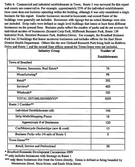
businesses are located along the Route 1 corridor (Table 4: Commercial
Resources). Although not directly located on Route 1, the Cherry
Hill Center does meet Route 1 at the I-95 connector and includes
Walmart.
In addition to the Route 1 corridor, there are clusters of businesses
scattered throughout the Town. For example, a number of small service
and retail establishments can be found in Stony Creek near the Town
Dock, on South Montowese Street (Route 146) near Linden Avenue,
and along Shore Drive (Route 142) in Short Beach. There are concentrations
of establishments surrounding the Town Green on Main Street and
Montowese Street and elsewhere in the center of Town, and a number
of stores are located on Cedar Street/Brushy Plain Road near Exit
54, and on Leetes Island Road on either side of I-95.
Industrial
Many manufacturers and industries are concentrated in industrial
and business parks in the eastern portion of Town. The major areas
include the business and industrial parks along Route 139 (Commercial
Street and Thompson Street), the industrial and manufacturing parks
off of Route 1 (Sycamore Way, Northeast Industrial and School Ground
Roads (behind the Chowder Pot)), and the cluster of businesses off
of Leetes Island Road near Exit 56 on I-95 (East Industrial Road
and Business Park Road). There are some smaller clusters of businesses
that are scattered throughout the Town such as the establishments
located on Meadow Street north of the train station (i.e., Atlantic
Wire) and the area between Bradley Street and Elm Street (i.e.,
future home of Cherry Hill Glass Co. at the old Nutmeg Steel plant).
|